Geographical Economical Model for Potential Sites Identification for Renewable Energies (GEMPIRE)
Small-scale analyses
The consideration of geoinformation in analysis and decision-making processes is becoming increasingly important due to the progressive decentralization of the energy industry – both in terms of generation and consumption. Examples include potential areas for wind power and solar ground-mounted systems or small-scale forecast distribution of electric car charging stations, heat pumps, rooftop PV systems, and other relevant generators and consumers, each subdivided by private and commercial use as well as forecast years. Everything is possible, from a house-by-house analysis of past developments to long-term forecasts of Europe-wide site potential analyses, thanks to r2b’s in-depth GIS expertise. In Germany, planning documentation for state development, regional and land use must also be included in the analyses. Their anticipated developments can also be forecast and mapped. To evaluate the economic value of identified sites, we also use high-quality weather data on wind speeds and solar irradiation in different spatial (from 250m) and temporal resolutions (from hourly values) for 14 meteorological years, in order to generate site-specific generation forecasts and time series.
The GEMPIRE model
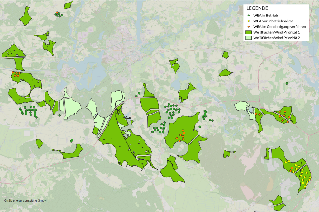
In order to identify suitable sites for wind power and photovoltaic plants efficiently and comprehensively using potential area analysis, our GIS team has built up an extensive database for the whole of Europe over many years and has developed automated GIS models for each technology: Our GEMPIRE (Geographical Economical Models for Potential Sites Identification for Renewable Energies). The parameterization of these models allows a flexible combination of many exclusion criteria in order to represent region-specific conditions or to calculate several scenarios.
Due to the constant and long-term optimization of the models and the database as well as our high-performance servers, a calculation of potential areas for entire federal states is possible within a very short time without any problems and in a resource-saving way.
Please contact our subsidiary solarea GmbH, which also offers services in the field of site acquisition for renewable energies.
Regionalized analyses
For precise modeling of future developments in the energy sector, regionalization on different spatial scales is necessary, because regional conditions of energy generation and load are depending on many factors such as population figures, economic and infrastructural conditions. Therefore, we use different methods for (dis)aggregation on administrative levels such as NUTS regions, Local Administration Units or postal code areas. If these political boundaries prove unsuitable for the issues at hand, we also generate subregions based on typical load or generation characteristics for further modeling.
What can we do for you?
Do you have questions about this or any other model? We will be happy to help you and look forward to hearing from you. Call us or simply write us your request by e-mail.